


Literally
Tropical Storm Gordon Moving Into Gulf of Mexico as it Soaks South Florida; Hurricane Watch and Tropical Storm Warnings Posted

At a Glance
The National Hurricane Center has now issued a hurricane watch from the mouth of the Pearl River, Mississippi, to the border between Alabama and Florida.
A hurricane watch means hurricane-force winds (74-plus mph) are possible in the area indicated beginning late Tuesday or Tuesday night.
Tropical storm warnings are posted for South Florida, from Golden Beach on the southeastern coast to Bonita Beach on the southwestern coast, as well as for the Keys, from Craig Key to Ocean Reef.
Tropical storm warnings are also posted from the Okaloosa-Walton County border in Florida westward to east of Morgan City, Louisiana, including Lake Pontchartrain and Lake Maurepas.
A tropical storm warning is typically issued when tropical-storm-force winds (39-plus mph) are expected in 36 hours or less.
Residents along the northern Gulf Coast should continue to make preparations for Gordon through Tuesday morning.
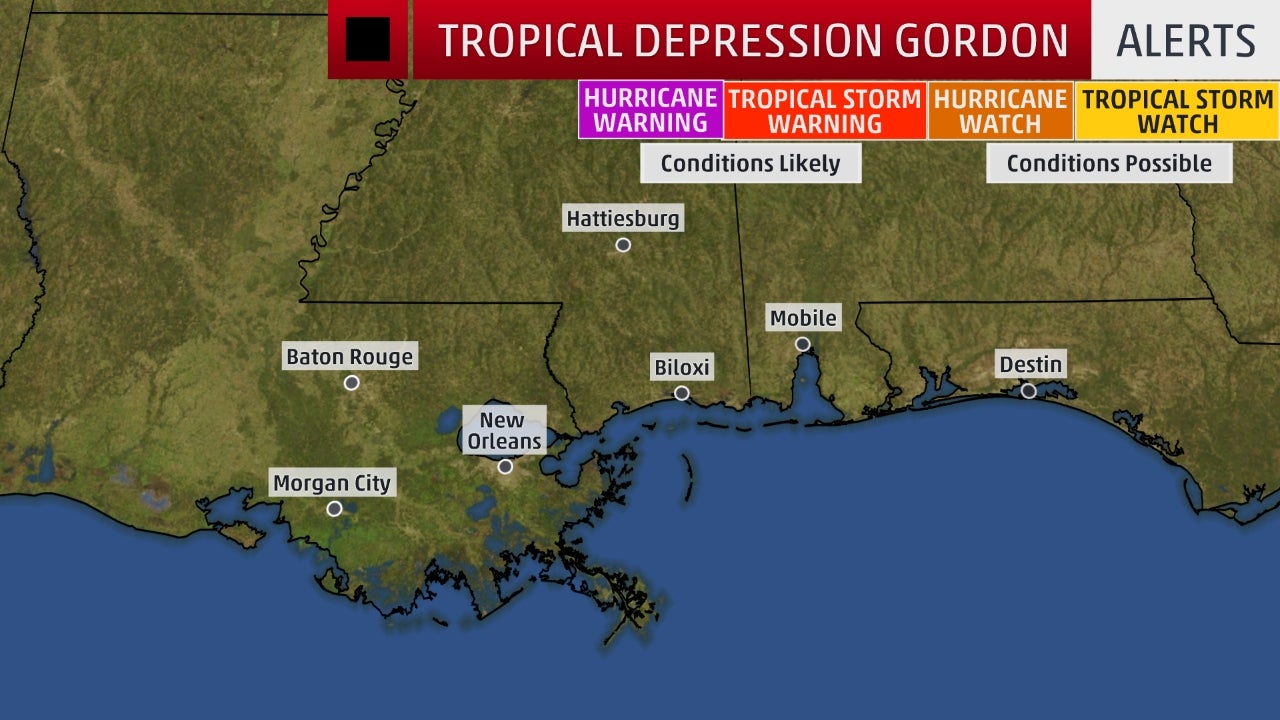
Watches and Warnings
(A tropical storm watch means tropical storm conditions are possible within 48 hours. A warning means those conditions are expected within 36 hours.)
(MORE: Hurricane Central)
Current Status and Forecast
Gordon is currently centered about 15 miles west-southwest of Marco Island, Florida, and is producing numerous showers and thunderstorms in southern Florida.
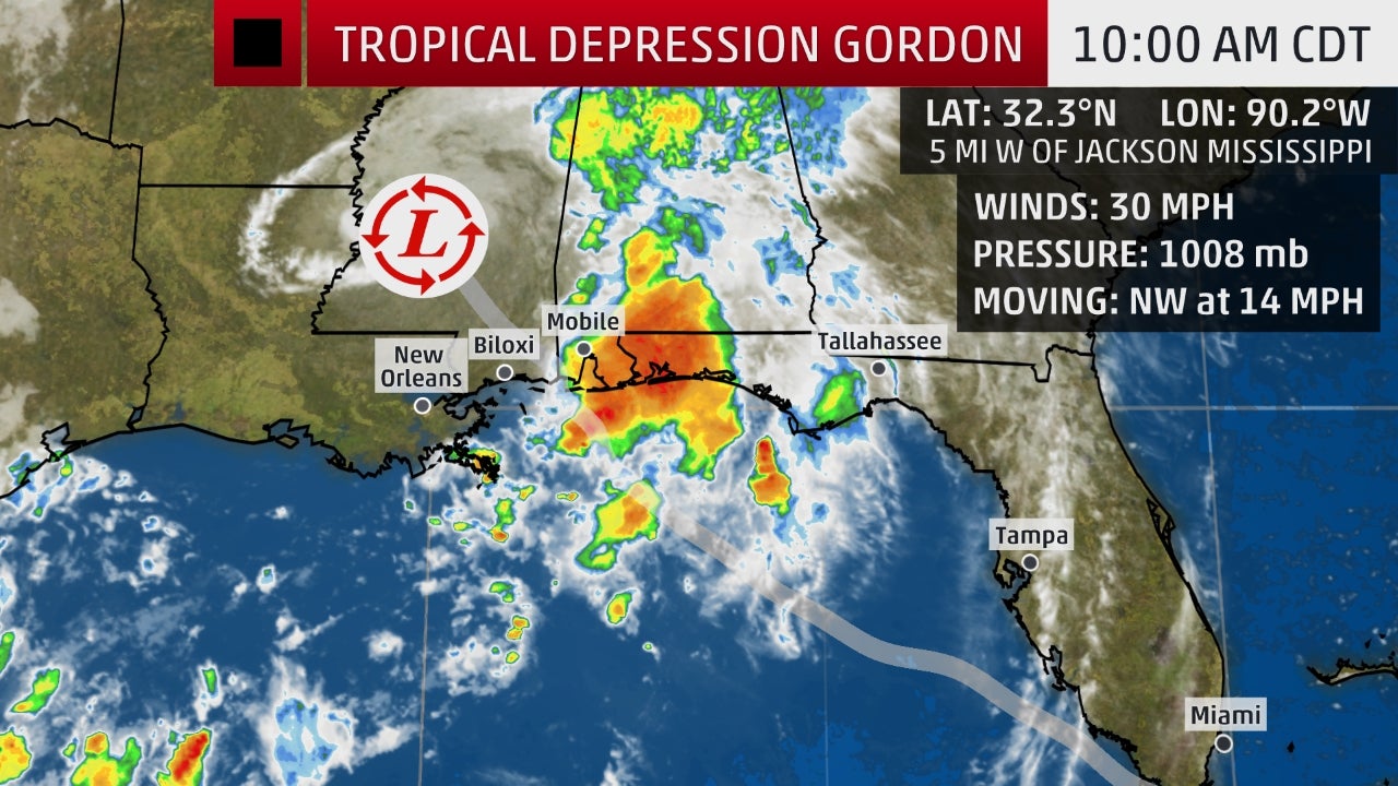
Current Storm Status
(The highest cloud tops, corresponding to the most vigorous convection, are shown in the brightest red colors. Clustering, deep convection around the center is a sign of a healthy tropical cyclone.)
Localized flooding is possible, and the National Weather Service has issued a flood watch for South Florida into Monday night.
In addition, tropical-storm-force winds (39 mph or greater) are possible in the tropical storm warning area in southern Florida on Monday. A wind gust to 51 mph was reported at Miami's Opa Locka Executive Airport on Monday morning.
An isolated tornado threat cannot be ruled out through Monday night across the southern and west-central Florida Peninsula, as well.
Current Radar, Watches and Warnings
(Watches and warnings are issued by the National Weather Service.)
Conditions should begin to improve Monday night in South Florida.
Steered by high pressure aloft parked over the eastern United States, Gordon will move through the eastern Gulf of Mexico Monday night through Tuesday.
Gordon is forecast to be a strong tropical storm near the time it makes landfall on the northern Gulf Coast Tuesday night, most likely in southeastern Louisiana, southern Mississippi or southern Alabama. There is some chance Gordon could attain Category 1 hurricane strength just before landfall, and that's why the NHC issued a hurricane watch for parts of the Mississippi and Alabama coasts.
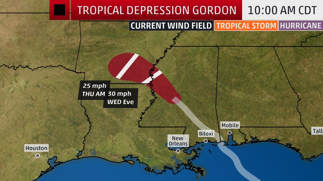
Projected Path
(The red-shaded area denotes the forecast path of the center of Gordon. Note that impacts (particularly heavy rain, high surf, coastal flooding) from Gordon may spread beyond its forecast path.)
Northern Gulf Coast Impacts
Here's a look at the current forecast impacts for Gordon, but keep in mind, changes are possible based on future adjustments to track and intensity.
Rainfall
Parts of the northern Gulf Coast could see 4 to 6 inches of rainfall Tuesday through Wednesday, from southeastern Louisiana into far southern Mississippi and far southern Alabama. Localized totals of 8 inches or more are possible in some areas by early Thursday.
As a result, there could be flooding in this region, including the New Orleans and Mobile, Alabama, metro areas. A flash flood watch has been posted by the National Weather Service for parts of southeastern Louisiana, southern Mississippi and coastal Alabama.
Separate flash flood watches are in effect in southeastern Texas and southwestern Louisiana due to heavy rain from another weather system affecting that region on Monday.
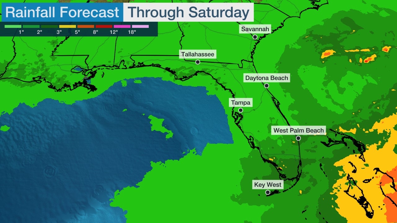
Rainfall Outlook
(This should be interpreted as a broad outlook of where the heaviest rain may fall. Higher amounts may occur where bands or clusters of thunderstorms stall for over a period of a few hours.)
Storm Surge, Rip Currents and High Surf
A storm surge warning has been issued from Shell Beach, Louisiana, to Mississippi-Alabama border. This means within 36 hours, parts of this coastline could see a dangerous, life-threatening storm-surge inundation.
There is a storm surge watch posted from west of Shell Beach, Louisiana, to the mouth of the Mississippi River and from the border between Mississippi and Alabama to Navarre, Florida.
Storm Surge Watches and Warnings
The NHC said water could reach the following heights above ground somewhere in the indicated areas if the peak surge occurs at the time of high tide:
Storm-Surge Inundation Forecast
(Values indicated are water levels above ground if the peak surge coincides with the time of high tide.)
High tide this week on the Louisiana and Mississippi coastline is in the early-morning hours. Tuesday morning through Thursday evening is the timing for potential coastal flooding in the storm surge watch area, according to the National Weather Service.
The deepest water will occur along the immediate coast near and to the east of the landfall location, where the surge will be accompanied by large waves, according to the NHC.
An onshore wind flow will continue a risk of dangerous rip currents on the northern Gulf Coast into midweek, and swimmers are encouraged to stay out of the water.
Seas are expected to build to 6 to 10 feet by Tuesday, according to the National Weather Service in Mobile, Alabama.
Wind
Tropical-storm-force winds (39-plus mph) are possible in the tropical storm warning area in South Florida on Monday.
By late Tuesday, tropical-storm-force winds could arrive on the northern Gulf Coast in the tropical storm warning area. Hurricane-force winds are possible in the hurricane watch area late Tuesday or Tuesday night.
Downed trees and power outages are expected where the tropical storm warning and hurricane watch are posted along the northern Gulf Coast. This is expected no matter whether Gordon is a strong tropical storm or a Category 1hurricane at landfall.
Tropical-Storm-Force Wind Probabilities
(The contours above show the chance of tropical-storm-force winds (at least 39 mph), according to the latest forecast by the National Hurricane Center.)
Check back with weather.com for the latest as we track Gordon in the Gulf of Mexico this week.
Tropical Storm Gordon Moving Into Gulf of Mexico as it Soaks South Florida; Hurricane Watch and Tropical Storm Warnings Posted
At a Glance
- Tropical Storm Gordon is now moving into the Gulf of Mexico.
- Soaking rainfall and gusty winds from Gordon are currently spreading across southern Florida.
- Tropical storm warnings are posted for South Florida and the northern Gulf Coast.
- A hurricane watch is now in effect for the Alabama and Mississippi coasts.
- Heavy rain, storm-surge flooding and strong winds are possible impacts from Gordon on the Gulf Coast.
- Storm surge warnings and watches are also in effect for a part of the northern Gulf Coast.
The National Hurricane Center has now issued a hurricane watch from the mouth of the Pearl River, Mississippi, to the border between Alabama and Florida.
A hurricane watch means hurricane-force winds (74-plus mph) are possible in the area indicated beginning late Tuesday or Tuesday night.
Tropical storm warnings are posted for South Florida, from Golden Beach on the southeastern coast to Bonita Beach on the southwestern coast, as well as for the Keys, from Craig Key to Ocean Reef.
Tropical storm warnings are also posted from the Okaloosa-Walton County border in Florida westward to east of Morgan City, Louisiana, including Lake Pontchartrain and Lake Maurepas.
A tropical storm warning is typically issued when tropical-storm-force winds (39-plus mph) are expected in 36 hours or less.
Residents along the northern Gulf Coast should continue to make preparations for Gordon through Tuesday morning.
Watches and Warnings
(A tropical storm watch means tropical storm conditions are possible within 48 hours. A warning means those conditions are expected within 36 hours.)
(MORE: Hurricane Central)
Current Status and Forecast
Gordon is currently centered about 15 miles west-southwest of Marco Island, Florida, and is producing numerous showers and thunderstorms in southern Florida.
Current Storm Status
(The highest cloud tops, corresponding to the most vigorous convection, are shown in the brightest red colors. Clustering, deep convection around the center is a sign of a healthy tropical cyclone.)
Localized flooding is possible, and the National Weather Service has issued a flood watch for South Florida into Monday night.
In addition, tropical-storm-force winds (39 mph or greater) are possible in the tropical storm warning area in southern Florida on Monday. A wind gust to 51 mph was reported at Miami's Opa Locka Executive Airport on Monday morning.
An isolated tornado threat cannot be ruled out through Monday night across the southern and west-central Florida Peninsula, as well.
Current Radar, Watches and Warnings
(Watches and warnings are issued by the National Weather Service.)
Conditions should begin to improve Monday night in South Florida.
Steered by high pressure aloft parked over the eastern United States, Gordon will move through the eastern Gulf of Mexico Monday night through Tuesday.
Gordon is forecast to be a strong tropical storm near the time it makes landfall on the northern Gulf Coast Tuesday night, most likely in southeastern Louisiana, southern Mississippi or southern Alabama. There is some chance Gordon could attain Category 1 hurricane strength just before landfall, and that's why the NHC issued a hurricane watch for parts of the Mississippi and Alabama coasts.
Projected Path
(The red-shaded area denotes the forecast path of the center of Gordon. Note that impacts (particularly heavy rain, high surf, coastal flooding) from Gordon may spread beyond its forecast path.)
Northern Gulf Coast Impacts
Here's a look at the current forecast impacts for Gordon, but keep in mind, changes are possible based on future adjustments to track and intensity.
Rainfall
Parts of the northern Gulf Coast could see 4 to 6 inches of rainfall Tuesday through Wednesday, from southeastern Louisiana into far southern Mississippi and far southern Alabama. Localized totals of 8 inches or more are possible in some areas by early Thursday.
As a result, there could be flooding in this region, including the New Orleans and Mobile, Alabama, metro areas. A flash flood watch has been posted by the National Weather Service for parts of southeastern Louisiana, southern Mississippi and coastal Alabama.
Separate flash flood watches are in effect in southeastern Texas and southwestern Louisiana due to heavy rain from another weather system affecting that region on Monday.
Rainfall Outlook
(This should be interpreted as a broad outlook of where the heaviest rain may fall. Higher amounts may occur where bands or clusters of thunderstorms stall for over a period of a few hours.)
Storm Surge, Rip Currents and High Surf
A storm surge warning has been issued from Shell Beach, Louisiana, to Mississippi-Alabama border. This means within 36 hours, parts of this coastline could see a dangerous, life-threatening storm-surge inundation.
There is a storm surge watch posted from west of Shell Beach, Louisiana, to the mouth of the Mississippi River and from the border between Mississippi and Alabama to Navarre, Florida.
Storm Surge Watches and Warnings
The NHC said water could reach the following heights above ground somewhere in the indicated areas if the peak surge occurs at the time of high tide:
- Shell Beach, Louisiana, to the Mississippi-Alabama border: 3 to 5 feet
- Navarre, Florida, to the Mississippi-Alabama border: 2 to 4 feet
- Shell Beach, Louisiana, to the mouth of Mississippi River: 2 to 4 feet
- Mouth of the Mississippi River to the Louisiana-Texas border: 1 to 2 feet
Storm-Surge Inundation Forecast
(Values indicated are water levels above ground if the peak surge coincides with the time of high tide.)
High tide this week on the Louisiana and Mississippi coastline is in the early-morning hours. Tuesday morning through Thursday evening is the timing for potential coastal flooding in the storm surge watch area, according to the National Weather Service.
The deepest water will occur along the immediate coast near and to the east of the landfall location, where the surge will be accompanied by large waves, according to the NHC.
An onshore wind flow will continue a risk of dangerous rip currents on the northern Gulf Coast into midweek, and swimmers are encouraged to stay out of the water.
Seas are expected to build to 6 to 10 feet by Tuesday, according to the National Weather Service in Mobile, Alabama.
Wind
Tropical-storm-force winds (39-plus mph) are possible in the tropical storm warning area in South Florida on Monday.
By late Tuesday, tropical-storm-force winds could arrive on the northern Gulf Coast in the tropical storm warning area. Hurricane-force winds are possible in the hurricane watch area late Tuesday or Tuesday night.
Downed trees and power outages are expected where the tropical storm warning and hurricane watch are posted along the northern Gulf Coast. This is expected no matter whether Gordon is a strong tropical storm or a Category 1hurricane at landfall.
Tropical-Storm-Force Wind Probabilities
(The contours above show the chance of tropical-storm-force winds (at least 39 mph), according to the latest forecast by the National Hurricane Center.)
Check back with weather.com for the latest as we track Gordon in the Gulf of Mexico this week.