You are using an out of date browser. It may not display this or other websites correctly.
You should upgrade or use an alternative browser.
You should upgrade or use an alternative browser.
This site may earn a commission from merchant affiliate
links, including eBay, Amazon, and others.
I am guessing still to much money floating around to have it nailed down. More palms to grease to ensure the highest "supporters" benefit the greatest.

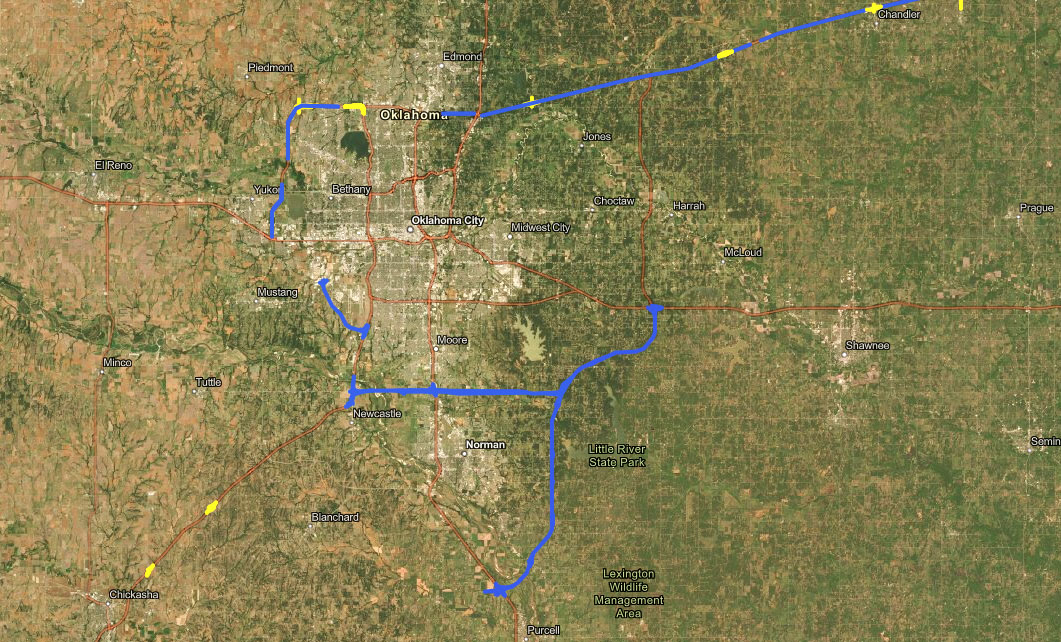
ACCESS Oklahoma, which stands for Advancing and Connecting Communities and Economies Safely Statewide, is a comprehensive, long-range planning process that looks at ongoing highway infrastructure needs for the next 15 years. It is designed to improve access to communities and help meet the state’s future infrastructure needs. This is the first plan of its type by OTA, and it will complement the agency’s five-year Capital Improvement Program.
Stitt, an ex-officio member of the board, and Gatz highlighted for the board the benefits ACCESS Oklahoma will bring to the state and previewed the proposed new turnpike alignments.
“The future of our economy will depend on having a modern highway system that manages congestion and reliable travel times,” Stitt said. “ACCESS Oklahoma is a bold investment in our future that provides needed corridor connections and expansions while making travel easier and leading to more economic development across the state.”
Features of ACCESS Oklahoma include:
- Widening the Turner Turnpike to six lanes between Oklahoma City and Bristow, which will create a six-lane highway for the entirety of the turnpike between the state’s two largest metros.
- The construction of reliever routes around Oklahoma’s two largest metropolitan areas.
- Off- and on-ramps constructed on the existing turnpike system, improving traffic safety for additional rural Oklahoma communities.
Many communities have offered tremendous positive feedback on the future of the turnpike system following the completion of recent projects such as the Kickapoo Turnpike in eastern Oklahoma County and the John Kilpatrick extension in southwest Oklahoma City as well as the ongoing Gilcrease Expressway project. These communities are seeking opportunities to coordinate infrastructure planning with their ongoing economic development efforts.
“ACCESS Oklahoma is a strategic corridor plan that focuses on travel time reliability, easing congestion in our metro areas, moving freight across the state and adding access to communities that previously were not connected to turnpikes,” Gatz said. “Addressing these needs will directly impact citizens’ quality of life while enhancing the state’s infrastructure for future growth. But most importantly, each of these projects will improve highway safety for motorists.”
The board hired Poe & Associates, an Oklahoma City-based engineering consultant, during the January 2022 board meeting to provide program management services for ACCESS Oklahoma’s long-range plan projects.
ACCESS Oklahoma will be fully paid for with bonds and will not affect any part of the state budgeting process. Revenue will not be diverted from other state priorities. Revenues from tolls, investments and concession leases pay all operating and maintenance costs for the turnpikes and pay off the bonds issued to finance their construction.
To learn more about the plan, go to www.AccessOklahoma.com.
I just have to wonder just how many people will lose their homes or business because of the routes proposed?
A lot.I just have to wonder just how many people will lose their homes or business because of the routes proposed?
Land, houses, cattle lease, etc.
Many people have been established a very long time in the country...
Doesn’t matter……..politicians + money = people getting screwed.I just have to wonder just how many people will lose their homes or business because of the routes proposed?
The ACCESS Oklahoma site in 1911Sooner’s post has a good map showing the corridors.Has anybody seen a good map for the eastern turnpike extension from I40 to I35 near Purcell? I've seen some generalized maps but nothing i can zoom in on and actually see where it's proposed.
It looks like the north-south corridor through east Norman is about two miles east of where it was expected to go about 25 years ago.
At least one - got a buddy whose dream patch outside the suburbs is about to have an overpass on his head.I just have to wonder just how many people will lose their homes or business because of the routes proposed?

On my phone, it’s on the main page, under the section “Project Map.”

Similar threads
- Replies
- 2
- Views
- 190
- Sub Category: Rifles
- Sale Price: 1500$
- Caliber: 22-250
- Replies
- 0
- Views
- 239
Join the conversation!
Join today and get all the highlights of this community direct to your inbox. It's FREE!
- Curated content sent daily, so you get what's interesting to you!
- No ads, no large blocks of text, just highlights for easy digest
- It's all totally free!
Enter your email address to join:
Thank you for joining!
Already
a member? Click here to log in


