Flooding in Tulsa

This site may earn a commission from merchant affiliate links, including eBay, Amazon, and others.

SoonerP226

Sharpshooter
Special Hen
Joined
Jan 1, 2013
Messages
13,600
Reaction score
14,205
Location
Norman
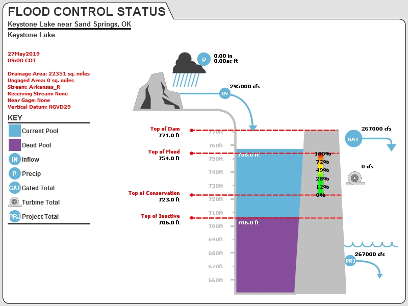
Sheesh guys, looks like another line of storms may be headed your way... :/
At this point, a line of storms headed our way isn't such a big deal (twisters excluded) when compared to the hellacious rain that's falling over the Arkansas drainage basin in Kansas and Nebraska. That's what'll keep Kaw, Keystone, and the Arkansas up.
 

MacFromOK

Sharpshooter
Special Hen
Joined
May 11, 2016
Messages
13,759
Reaction score
14,758
Location
Southern Oklahoma
At this point, a line of storms headed our way isn't such a big deal (twisters excluded) when compared to the hellacious rain that's falling over the Arkansas drainage basin in Kansas and Nebraska. That's what'll keep Kaw, Keystone, and the Arkansas up.
Yeah, but the way it's looking, you may get local rain along with all that.

Good luck. Here's hoping it fizzles out pretty quick.
:drunk2:
 

dennishoddy

Sharpshooter
Supporting Member
Special Hen Supporter
Joined
Dec 9, 2008
Messages
84,915
Reaction score
62,750
Location
Ponca City Ok
At this point, a line of storms headed our way isn't such a big deal (twisters excluded) when compared to the hellacious rain that's falling over the Arkansas drainage basin in Kansas and Nebraska. That's what'll keep Kaw, Keystone, and the Arkansas up.

Yep, it's amazing when going through Dodge city Ks and crossing the Arkansas river. It's dry typically in the summer. The same river in Canyon City Co. is a raging class IV rapids with fishing reports of rainbow and brown trout.
The irrigation systems rob the water from the river in that area unless there is a lot of rain like now. Downstream toward Wichita, several creeks and streams keep the Arkansas River alive and flowing. It's a huge watershed that feeds Kaw, Keystone, and the Kerr MccLellan navigation system.
It didn't help when the massive floods in Nebraska and the upper mississippi river watershed got rains like we are going through meaning the COE had to hold water in our reservoirs to allow the Mississippi river to drain before we added to it resulting in the record floods we have now.
All that being said, I can remember before the Kaw and Keystone dams were built. This same flood issue was even worse back then because there was no way to control it. It happened every year and was much higher. Mother Nature controlled everything.

What we have now is a controlled release that in the end will save more property than it would have in the past. It's great to see a long term plan come into fruition.
Complacency with low river levels over the years encouraged folks to build close to the rivers for the view and esthetics, and that is the fault of the city/county planners, not the COE.
When massive floods hit Coffeyville Ks years ago, the city bought out all of the properties in that location that flooded and made it into a city park that can flood and not have major consequences.
The Dixie Dog drive in in Ponca that has been featured in several of these flood photos around the national news networks was underwater every year with the floods before the dam was built. The new owners built up the ground with that in mind even though the dam was in existence, and guess what....they are above water and operating today.
This is a terrible situation for a lot of folks and our hearts go out to them and hope for a recovery that is the least devastating.
There is a major rain event happening right now in the Kansas area that drains into the Kaw watershed, and there is more predicted for tomorrow.
 
Last edited:

BReeves

Sharpshooter
Supporting Member
Special Hen Supporter
Joined
Feb 18, 2010
Messages
2,733
Reaction score
1,603
Location
Catoosa
Bad situation for those down river, heard on the radio this morning it could take up to a month (without rain) for the river to drain anywhere close to normal. Hope they are wrong.
 

Pokem807

Sharpshooter
Supporting Member
Special Hen Supporter
Joined
Apr 22, 2009
Messages
1,182
Reaction score
272
Location
Green Country
I saw in a news report that the Corps must keep Keystone below 757', and that maintaining that level is what will dictate release from the dam. Anybody know why that level is so critical? What happens if it's exceeded?
 

Shadowrider

Sharpshooter
Supporting Member
Special Hen Supporter
Joined
Jan 28, 2008
Messages
21,555
Reaction score
9,382
Location
Tornado Alley
I saw in a news report that the Corps must keep Keystone below 757', and that maintaining that level is what will dictate release from the dam. Anybody know why that level is so critical? What happens if it's exceeded?
Surcharge pool is 757'. That's above flood control pool. They have to release if it goes over SP because it put too much stress on the dam.
 
Last edited:

SoonerP226

Sharpshooter
Special Hen
Joined
Jan 1, 2013
Messages
13,600
Reaction score
14,205
Location
Norman
www.swt_wc.usace.army.mil_images_x_y_KEYS.lakepage.jpg
 

Latest posts

Top Bottom